VK3HJQ
![]()

APRS Page


Automatic Position Report System
APRS stands for Automatic Position Reporting System and now is taken to refer to a protocol that uses a subset of AX25 packet radio to provide a range of facilities not available to amateur radio before. The cornerstone of APRS is that the packets are sent using the BEACON text format - and do not require 'connects' to occur first. This way information can be widely distributed based on both conditions and other stations in the network. Packets are passed using level-2 digipeating which works most efficiently when full handshaking is not needed.
The more stations on air, the further packets will
propagate. All APRS stations should digipeat an unconnected packet with
RELAY in its path. Well placed stations also digipeat WIDE.
The activity on band regulates itself, when very busy distances covered are likely to be less.
UI-VIEW as a software package, and the latest firmware upgrades for the TINY-2 TNC both allow a measure of more intelligent digipeating, reducing the incidence of unnecessary digipeats.
* Live, simple single line text messaging with minimal bandwidth usage and the ability to support more than two people in the same conversation
* An on screen map showing the location (and if appropriate) the speed and direction of amateur stations in an area. The area could be be very local and show individual streets, or zoomed out to show the whole world.
* Weather information is available from local stations often via automated uploading
* Non-radio station objects of general interest can be placed on everyone s map by any station
* DX conditions make APRS more exciting (whereas regular packet become less efficient if signals propagate well)
* For mobile stations APRS offers an interesting add-on that need not (!) distract the driver but can create a point of interest for other users, and a talking point for new people to the hobby.
Internet gating makes long distance messaging possible from handheld radios and lets you watch the activity over the internet.
Radio direction finding improves the use of APRS in emergency network co-ordination.
APRS software is available for Microsoft Windows
(WinAPRS) , DOS (DOSAPRS), the Apple Macintosh (MacAPRS), the Palm PDA
(PocketAPRS) and (confusingly) the new PocketPC (APRS/CE). There is a
JAVA version for accessing IGATE (internet gateway) APRS traffic over
the web.
That is a very brief outline, and the full potential of APRS is well beyond the time I have available to study it, but not beyond Bob Bruninga - who first devised it and comes up with more new uses for the mode on a regular basis.
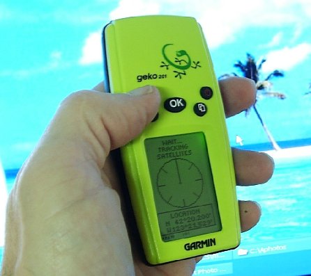
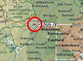
VK3HJQ-9 MOBILE APRS TRACKER
Garmin Geko 201, MFJ1270B TNC (New Eprom)![]() & FM92 Radio/CTCSS
& FM92 Radio/CTCSS
(NO MSG) Voice Alert PL91.5 (CTCSS 91.5Hz) 145.175 Mhz
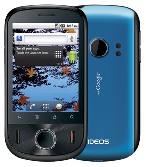
IDEOS SmartPhone
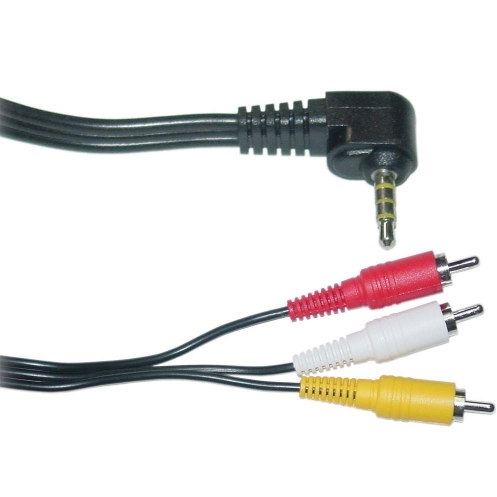
Phone lead 4 Pole TRRS (Cut RCA's off & wire direct to circuit board)
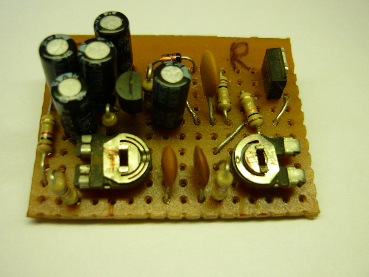
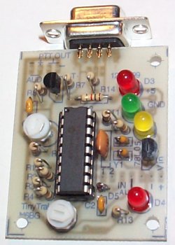
APRS Digital VOX Interface Board (Board layout & construction by Brian vk2tgs - circuit diagram below)
Now running the following.........
Andriod IDEOS Smart Phone/GPS, APRSdroid App. (SmartBeaconing), VOX Interface & Yaesu FT-270R
(NO MSG) 145.175 Mhz
VK3HJQ-1 W1(Wide1-1) Emergency Digipeater Tallangatta
Ui-View 2.03, APRS - Emergency Ver. 1.23, MFJ1270B TNC & FM92 Radio 145.175 Mhz
VK Freq. 145.175 Mhz
Satellite Freq. 144.390 Mhz
All you need is a 2mtr Radio, TNC & Computer {with software (ui-view)}
or for mobile (tracking) use a 2mtr radio, TNC (or Tiny Trak) & a GPS.
Tiny Trak by N6BG
Tiny Trak Circuit Diagram
Tiny Trak Owner's Manual
UIDIGI VK3HJQ-1 APRS TEST ONLY Digipeater
Version 1.8 BETA 6 (20001228) TNC2
Copyright 2000 Marco Savegnago IW3FQG
English Version
What is UIDIGI?
UIDIGI is firmware to use a TNC2 (or TNC2 clone) as an APRS packet digipeater with advanced functions.
(APRS is a register trademark of Bob Bruninga WB4APR)
Why UIDIGI?
Several reasons. But the bottom line is cost, availability, and performance !!! Cost because the TNC2/clone package
is the cheapest (when time to assemble is included in calculations), they are widely available, and most importantly,
UIDIGI brings features to the TNC2/clone that make it efficient for use in a complex APRS network.
VK3 Digipeaters from here on 145.175 Mhz
Tallangatta vk3hjq-1 W1 Emergency Digipeater
Bonegilla vk2cpr-1
Wodonga vk3kaw RX IGATE
Or
Albury vk2trl RX IGATE
For the Greater Seymour, Yea, Shepparton and Central Victorian area:
Fixed station: VK3RMG-1,VK3RMD-1 or VK3RMG-1,VK3MY-1 or VK3RGR-1,VK3RMG-1,VK3RMD-1
Mobile station: WIDE1-1,WIDE2-1 or WIDE1-1,WIDE2-2
For the Greater Shepparton and Central Victorian area:
Fixed station: VK3RMG-1,VK3RMD-1 or VK3RMG-1,VK3MY-1 or VK3RGR-1,VK3RMG-1,VK3MY-1
Mobile station: WIDE1-1,WIDE2-1
For the Greater Wangaratta, Benalla & NE Victoria area:
Fixed station: VK3RGR-1,VK3RMG-1,VK3RMD-1
Mobile station: WIDE1-1,WIDE2-1 or WIDE1-1,WIDE
For Albury/Wodonga area:
Fixed station: VK3RAW-1,VK3RGR-1,VK3RMG-1,VK3RMD-1
Mobile station: WIDE1-1,WIDE2-1 or WIDE1-1,WIDE2-2
For the Tocumwal area:
Fixed station: VK2RO-1,VK3RGR-1,VK3RMG-1,VK3RMD-1
Mobile station: WIDE1-1,WIDE2-1 or WIDE1-1,WIDE
News on new paths for VK3 as @10th November 2006
This is what we propose for VK3.

Setup: UI-View
aprs,vk3hjq-1,vk2cpr-1,WIDE2-1
Roger G4IDE is the author of the most popular APRS program in the UK.- UIVIEW available in 16bits (for use and evaluation) and 32bits (registers users)
UI-View APRS software & info.
UI-View setup information by VK4GO
================================================
(1) After installing the program do the following steps to setup the parameters for UI-View APRS operations.
(2) Go to the top main screen window and select Options. Only make tick
on the following settings Auto Refresh & amp; Show Monitor Window.
(3) If you have a TNC or Soundcard ... if not see number 7 (Internet)
Go to setup on the top and select Comm Setup. Select the Comsport and
your TNC model.There are a few options. You can make a choice what sort
TNC in Kiss mode you like to use, by selecting Host Mode and click
Setup to find you TNC model (PK-232, Kan, TNC2, TF). If you select
Hostmode AGW you can use a Soundcard or Baycom modem together with a
program AGWPE 2002-10
(4) Go to the setup in the main window and select station setup, fill
in callsign and the coordination where you are, like 27.59.81S and
153.25.79E then fill in beacon comment with your name, qth and your
email address sample: Art Carrara vk4go@bigpond.net.au then select Km
and internet beacon 30 and click ok.
(5) Go again to setup and select station text ticked on send best DX then ok again.
(6) Go to setup station info and fill in your Name,Qth and Email after you have finished click Ok again.
(7) Internet Connection.
This is how you setup the APRS internet connection.
Again setup and select APRS Server setup and select on the top in the
small window APRS.CLOUD.AU:10151 small traffic server or you like to
see more traffic 3000-4000 stations then select APRS.NET.AU:10151 for
Worldwide high traffic port then hit ok again.
(8) Now you go on the top and hit action and select connect aprs server.
It will connect then to VK3SB here in Melbourne and you will see stations coming from over the world ...
(9) There are a few more maps you can download from here
http://www.users.bigpond.net.au/vk4go/maps.zip unzip this in
UI-VIEW\MAPS directory.
(10) Now you can have a play with it see what happens.
(11) Here are some commands you can try with other stations ?ver? ?aprst ?aprsd ?ping? ?dx
(12) If you use the left mouse button, double click in front of a
callsign then you will see some info from that station, or do a right
click on that station and see what happens.
(13) Read the help files by pressing the F-1 key for every topic. Do not forget !!!!
(14) You can also broadcast APRS from the internet to VHF with a TNC or
a Baycom modem and soundcard by using a special program AWGPE. It is
also free.
(15) Good luck hope to work you on the APRS system
(16) Remember after you load more maps in the maps directory always refresh the maps list or restart the program.
73 de Art 20-04-2002
Email: vk4go@bigpond.net.au
UIVIEW APRS MAPS thanks to Geoff vk2xjg
VK3 APRS Info & Maps
LOCAL MAPS
Map of Victoria
Victoriamap.zip 187KB
Maps of Albury\Wodonga Tallangatta area
& Yackandandah to track vk3hjq-9
vk3hjqAlbTallmaps.zip 590KB
vk3hjqTallAlbWodmaps.zip 1,766KB

APRS has the ability to provide an emergency beacon that can be used when a person is in trouble.
The emergency beacon is similar to a PAN or SOS voice call. When an emergency beacon is received by other APRS station, it alerts the operator and provide the station with the location information associated with the transmission of the beacon.
If the receiving station is running an APRS enabled Kenwood hand held or mobile radio the radio will produce an audible alarm and display the bearing of the station sending the emergency beacon. If an emergency beacon is received by an APRS home station the station display may automatically zoom into the emergency beacons location and sound a alarm.
As the APRS system is linked international it is possible that a local emergency beacon will trigger thousands of APRS station alarms around the globe.
This is a powerful feature of APRS and is required to be used appropriately.
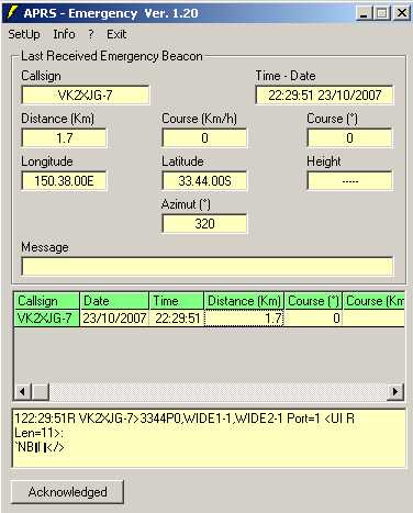
UI-View Reception of Emergency Beacons
UI-View can receive Emergency Beacons with the use of APRS-Emergency add-on software by Giuseppe IW2JZQ.
To install UI-Emergency first download both files below, unzip and install UI-Emergency1.1. Do not run the program after you have installed it. Download UI-Emergency Update1.2 , unzip the update file in to the 'APRS Emergency' directory. If you get asked to replace an existing file answer Yes as you need to replace the original file. You can now run UI-Emergency and configure it to your own liking.
New version 1.23 OUT NOW Now the program works fine with TNC connected directly to UI-View and with TNC managed by AGW-PE. This newer version will now also Decode an Emergency Symbol Beacon (standard or compressed ) sent from UI-View as well...
![]() Click here
Click here http://www.trilogysystem.it/HamRadio/software.asp,
![]() ( Lastest version )
( Lastest version )
by Giuseppe IW2JZQ. CopyRight trilogysystem - iw2jzq
VOICE ALERT
PL 91.5 [Private line 91.5 (CTCSS 91.5hz)] for Mobiles and Portables ONLY!
(Australia: National Freq.145.175 CTCSS 91.5Hz)
VOICE ALERT!  The concept called Voice Alert is like getting a FREE APRS voice calling channel
in your mobile for ALWAYS being able to contact an APRS mobile no matter what frequency the
voice radio is on. Its also like a radar detector for other mobile APRS operators in simplex range on the open road.
It is trivially simple:
Instead of turning the speaker volume down on your noisy 145.175 channel, simply set CTCSS decode to 91.5Hz.

This accomplishes 2 things:
1) It keeps your speaker quiet but everyone who understands voice alert knows they can contact you by voice by simply calling on PL 91.5.
2) It causes your outgoing packets to have PL 91.5 to serve as a radar ping to other Voice Alert stations in range.

Conversely, you will never hear anything on your 145.175 voice alert unless another APRS voice alert station is in simplex range.
These two make sure you will have an opportunity for a voice call and then to QSY to other channel for a QSO.
On the road you may pass another ham, but you never know it. With Voice Alert, you now will be
aware of each other's presence AND you will have a KNOWN contact frequency.
Mobiles and Portables only! NO BASE STATIONS or DIGIPEATERS please.
Mobile phone Cig. charger converted to run a Garmin eTrex or Geko
Switching Regulator circuit
add F1- 315ma 3AG Fuse
R1- 3.3ohm 1/2w Resistor
D1- IN4004
D2- 18v 5w Zener
1.5kohm in parallel across R5 in mine it was R8 1kohm= 600ohm not 150ohm
Vout=1.25(1+R4/R3)
MAX. VOLTAGE for an eTrex/Geko is 3.15volts ( 3v +/- 0.15v )@180ma
I set mine to 3.0v O/P @ 14.2v I/P to be on the safe side
Check out my eTrex link pages for more detailed info
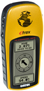
Garmin eTrex GPS
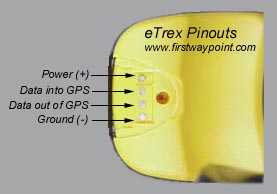
Plug Assembly for eTrex or Geko
APRS Digital VOX Interface Circuit
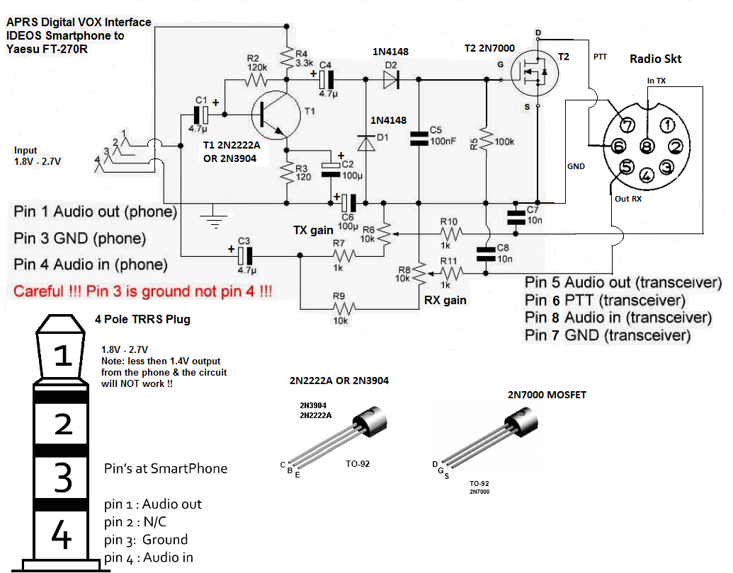
NOTE: Dave G4FRE/WWR2 Mod 02/14, he replaced the Darlington Transitor with a MOSFET 2N7000 (T2) for better PTT switching, this also means rewiring R5 & changing the resistor value as shown in the circuit above.
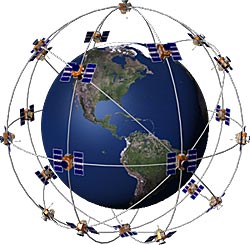
The GPS satellite system
The 24 satellites that make up the GPS space segment
are orbiting the earth about 12,000 miles above us. They are constantly
moving, making two complete orbits in less than 24 hours. These
satellites are travelling at speeds of roughly 7,000 miles an hour.
GPS satellites are powered by solar energy. They have backup batteries
onboard to keep them running in the event of a solar eclipse, when
there's no solar power. Small rocket boosters on each satellite keep
them flying in the correct path.
Here are some other interesting facts about the GPS satellites (also
called NAVSTAR, the official U.S. Department of Defense name for GPS):
What is WAAS ?
You've heard the term WAAS, seen it on packaging and ads for GARMIN products, maybe even know it stands for Wide Area Augmentation System. Okay, so what the heck is it? Basically, it's a system of satellites and ground stations that provide GPS signal corrections, giving you even better position accuracy. How much better? Try an average of up to five times better. A WAAS-capable receiver can give you a position accuracy of better than three meters, 95 percent of the time. And you don't have to purchase additional receiving equipment or pay service fees to utilize WAAS.
The origins of WAAS
The Federal Aviation Administration (FAA) and the Department of Transportation are developing the WAAS program for use in precision flight approaches. Currently, GPS alone does not meet the FAA's navigation requirements for accuracy, integrity and availability. WAAS corrects for GPS signal errors caused by ionospheric disturbances, timing and satellite orbit errors and provides vital integrity information regarding the health of each GPS satellite. Although WAAS has not yet been approved for aviation, the system is available for civilian use, such as for boaters and recreational GPS users.
How it Works
WAAS consists of approximately 25 ground reference stations positioned across the United States that monitor GPS satellite data. Two master stations, located on either coast, collect data from the reference stations and create a GPS correction message. This correction accounts for GPS satellite orbit and clock drift plus signal delays caused by the atmosphere and ionosphere. The corrected differential message is then broadcast through one of two geostationary satellites, or satellites with a fixed position over the equator. The information is compatible with the basic GPS signal structure, which means any WAAS-enabled GPS receiver can read the signal.
Who benefits from WAAS?
Currently, WAAS satellite coverage is only available in North America. There are no ground reference stations in South America, so even though GPS users there can receive WAAS, the signal has not been corrected and thus would not improve the accuracy of their unit. For some users in the U.S., the position of the satellites over the equator makes it difficult to receive the signals when trees or mountains obstruct the view of the horizon. WAAS signal reception is ideal for open land and marine applications. WAAS provides extended coverage both inland and offshore compared to the land-based DGPS (differential GPS) system. Another benefit of WAAS is that it does not require additional receiving equipment while DGPS does.
Other governments are developing similar satellite-based differential systems. In Asia, it's the Japanese Multi-Functional Satellite Augmentation System (MSAS), while Europe has the Euro Geostationary Navigation Overlay Service (EGNOS). Eventually, GPS users around the world will have access to precise position data using these and other compatible systems.
It just keeps getting better
| 100 meters: | Accuracy of the original GPS system, which was subject to accuracy degradation under the government-imposed Selective Availability (SA) program. | |
| 15 meters: | Typical GPS position accuracy without SA. | |
| 3-5 meters: | Typical differential GPS (DGPS) position accuracy. | |
| < 3 meters: | Typical WAAS position accuracy. |
VK3HJQ Home Page

© vk3hjq 2001-2022 All Rights Reserved. vk3hjq@hotmail.com